Our response to the Bournville and Cotteridge Places for People consultation
Filed under: Consultation / LTNs
This article is our consultation response to the Bournville and Cotteridge Places for People scheme. We support the aims of the scheme, which include reducing traffic in residential areas to:
- make them safer for pedestrians and cyclists
- make them more pleasant to live in
Our response highlights concerns about the scheme’s implementation.
The consultation process is unclear and does not provide essential information. The Council needs to publish a summary of key information to help residents respond. Consultation documents also use complicated terms for different parts of the scheme. For example, ‘modal filters’, ‘one-way streets’ and ‘shared-used paths’. We call for clearer definitions. The Council also needs to consider conflicts between people walking and cycling.
We raise concerns about the lack of connection with train stations and existing and proposed cycle routes. We question how effectively the scheme will reduce through-traffic in the area. We highlight the need for data about current pedestrian and cycling patterns. We ask for targets to prove if the scheme has succeeded or failed.
We question the engineering aspects of certain design elements, for example:
- on-road cycle routes
- one-way streets
- speed cushions
We ask the Council to consider local case studies and learn from previous experience. This will ensure the best outcomes for all.
We support the goals of Places for People. We ask for:
- clearer communication
- integration with existing infrastructure
- better data collection
- careful consideration of design elements
This will help the scheme to be effective in creating safer and more accessible streets for all.
If you agree with this, you can submit your response on the Birmingham Be Heard website before the 2 July 2023 and link to this page.
Our response
Introduction
We support the Council’s aims listed in the stated overview for this scheme:
Places for People aims to reduce traffic in residential neighbourhoods so that it is safer for people to walk and cycle, and nicer to be outside for children to play and neighbours to chat.
In many parts of Birmingham, residents find their streets are busy with traffic, particularly when people are taking shortcuts to avoid main roads. When traffic is reduced the neighbourhood becomes quieter, the air is cleaner, and streets feel safer.
The principle of Places for People is that residents can continue to drive onto their street, have visitors, get deliveries, etc, but it is made harder to drive straight through the area.
The consultation page on the Council’s website then lists the various elements they wish to implement, with a short description of each:
Modal filter – A bollard (or planter) that stops vehicles driving all the way along a street whilst retaining full access for pedestrians and cyclists.
One-way streets – Streets that only allow traffic in one direction, access for critical amenities, such as shops and schools is maintained.
Segregated cycle track – These cycle routes allocate a section of the carriageway/ footway for cycle use only. Some physical separation is often used to stop motor vehicles from entering the space.
On street cycle route – A section of street suitable for cyclists to mix with general traffic, due to low vehicle speed and volume.
Shared use path – A shared path is designed for all types of users including pedestrians, wheelchair users and cyclists. Shared paths may be identified by signs showing a white bicycle and pedestrians on a blue background.
Signalised crossing – Crossings that are controlled by traffic signals for pedestrians, cyclists and vehicles, often used where vehicle speeds are high or where there is a high number of pedestrians and cyclists.
Raised zebra/parallel crossing – Raised zebra crossings combine traffic calming measures with pedestrian crossings, raised parallel crossings include the provision for cyclists to cross without having to dismount. These crossings encourage drivers to travel at their slowest where pedestrians and cyclists are crossing.
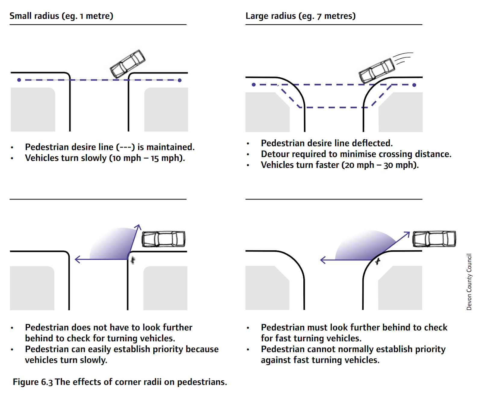
Kerb adjustments at junction – The corners of the kerb line at junctions are tightened, which forces vehicles to navigate the junction at a slower speed, widens the footway at the junction, and reduces the crossing distance for pedestrians.
Traffic Calming – Measures such as speed cushions, speed humps and chicanes can be introduced to keep a street open to all traffic but to discourage its use by those who don’t need to use it for local trips.
There is further information about the different elements in an attached “Frequently asked questions” document, a recording of a briefing that took place on 15 June 2023 (one hour long) and other related material.
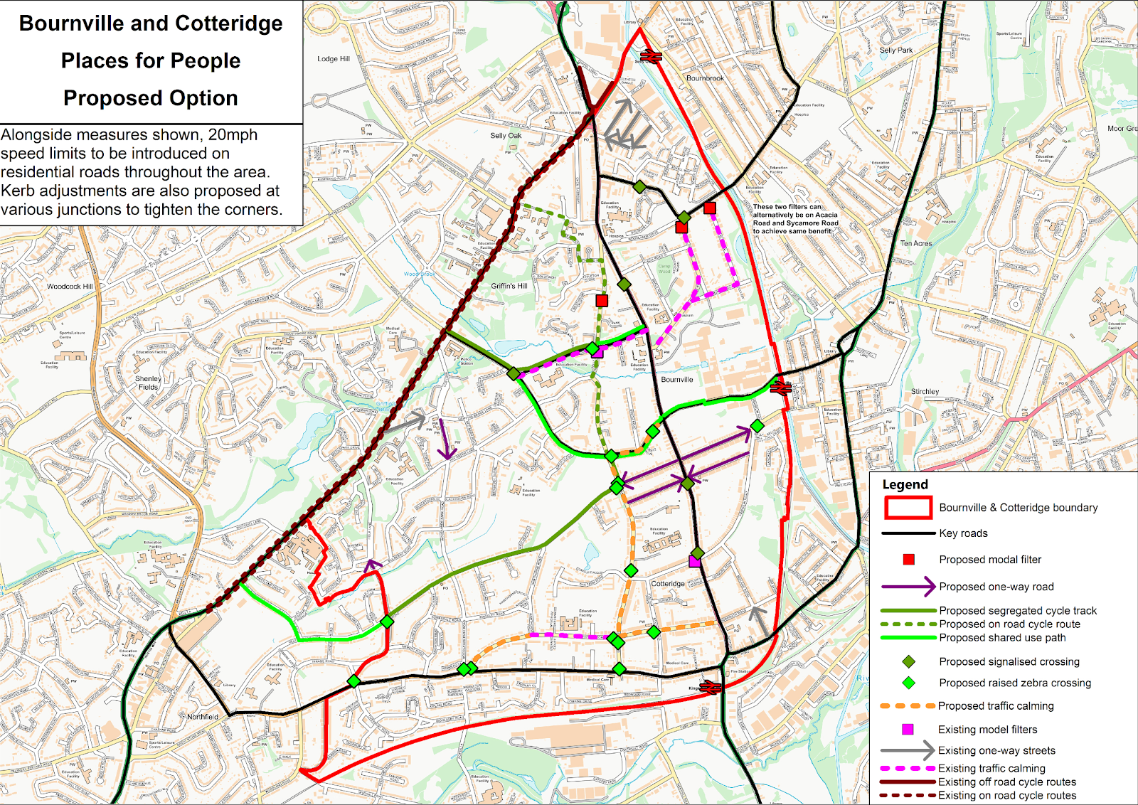
There is also a plan of the area with the proposed locations of the various elements:
We completely support the goals of the Places for People initiative, not least in light of the horrific danger posed by dangerous driving on Birmingham’s roads.
We also note the goals accord with a number of Birmingham City Council’s important strategies:
- Birmingham Cycle Revolution
- Birmingham Transport Plan
- Local Cycling and Walking Infrastructure Plan (LCWIP)
- Route to Zero climate emergency targets
- Fit for the Future Childhood Obesity Strategy
However, we have serious concerns about elements of this scheme which we urge the Council to consider:
The consultation is difficult to understand and omits information that the public may find useful
We note the consultation links to material including the recorded briefing, transport study, frequently asked questions document and other information. However, we are concerned that not everyone will watch an hour-long recording and open and read multiple attached documents. There is a benefit in ensuring the key information is summarised, concise and descriptive to ensure informed consultation responses. We believe the top-level information could be improved to this end:
Modal filters
The description of modal filters is ambiguous and ignores vital benefits. There are better definitions that can be used or adapted, for example:
Perhaps the single most important tool to promote cycling may be the humble bollard, used to prevent through traffic. It is relatively inexpensive and can be erected quickly…. such low-cost modal filters can increase safety by reducing through traffic, while retaining cycle and pedestrian access. Provided they have real effect, swift, pragmatic interventions are preferred over elaborate and costly ones.
Department for Transport
In its simplest form, a modal filter is a physical restriction (a row of bollards, for example) which people can travel through by walking, wheeling or cycling, but not by motor vehicle.
Sustrans
A modal filter is a feature used to limit through-journeys along a street by certain modes of transport [motor vehicles]. Modal filters are used to achieve filtered permeability and are part of the toolbox of low traffic neighbourhoods.
Cycling Embassy of Great Britain
A point closure is another term for a filter. However, ‘modal filter’ is the recommended term, because these measures do not actually ‘close’ the street to people walking and cycling, they only prevent motor traffic passing through a specific point, or from driving through an area.
Cycling Embassy of Great Britain
One-way streets
The description for one-way streets does not include any explanation as to how they promote the Places for People aims. As a design intervention they do not make it easier to cycle, nor make it safer for children to play outside and have only a limited impact on shortcuts.
To compare a car study, the old one-way streets off Kings Heath High Street allowed through-traffic, had traffic calming and yet were removed as part of that Places for People scheme because they were rat runs and unsafe for cycling. The modal filters created a network of quiet side roads that enable cycling. There are newly proposed one-way streets in Kings Heath, but their key element is that they are loops that prevent through traffic.
The proposals in the consultation do not appear to have learnt lessons from other areas of Birmingham.
The description of shared use path does not explain how they will be “designed for all types of users including pedestrians, wheelchair users and cyclists”.
In urban areas, the conversion of a footway to shared use should be regarded as a last resort. Shared use facilities are generally not favoured by either pedestrians or cyclists, particularly when flows are high. It can create particular difficulties for visually impaired people. Actual conflict may be rare, but the interactions between people moving at different speeds can be perceived to be unsafe and inaccessible, particularly by vulnerable pedestrians. This adversely affects the comfort of both types of user, as well as directness for the cyclist.
Cycle infrastructure design guidance
This appears contrary to the aims of Places for People and, if the proposed design does address these concerns, it should be explained how in the consultation.
Kerb adjustments at junctions
We welcome the proposal for kerb adjustments at junctions. The consultation may be improved by clearly showing a diagram of how the benefits are realised. The Manual for Streets is a good example:
The description of traffic calming includes reference to speed cushions without clarifying that these are described in cycle infrastructure guidance as “not a preferred form of traffic calming on cycle routes because they constrain the ability of cyclists to choose their preferred position in the carriageway and are particularly hazardous to riders of three wheeled cycles”. Better Streets for Birmingham has already highlighted negative impacts of speed cushions in our response to the Russell Road consultation and as such we are particularly disappointed that has been ignored.
There appears to be a low traffic neighbourhood (LTN) within the proposal, yet a definition of this is absent from the consultation. We appreciate the term itself can be provocative, however they are an intervention with a broadly agreed definition:
‘Low Traffic Neighbourhoods’ (LTNs) are area-based interventions that use ‘modal filters’ (planters, bollards, or camera gates) to remove through motor traffic from residential streets.
Aldred and Goodman, 2021
Birmingham has many LTNs, some decades old. See for example the area of Bournville around Kingfisher Way. This area was designed to minimise through traffic. Birmingham City Council may adopt a different label and local definition, as some other authorities have done, but we believe they are one of many important interventions to realise the Places for People aims and not labelling them is counterproductive.
Related but separately funded schemes
It would also be helpful to explain that the Places for People scheme is not a single one-off intervention. It’s aims will be supported by:
- a series of local schemes, such as the traffic calming works to be done at the junction of Bournville Lane and Selly Oak Road which has been proposed in response to the concerns of local residents about the safety of the crossing
- the ongoing continuing implementation of the Birmingham Transport Plan, including for example the introduction of the city centre circulation plan
- future steps to be developed – and consulted on – in response to the result of the implementation of the current scheme. This could, for example, include further work to improve the area around Bournville Green.
On a more general point, none of the amenities (schools, GPs, shopping areas, places of work, places of worship, bus routes) are marked on the consultation map. People travel along routes to and from places. The design process should clearly take routes into account, and this process should be clearly explained in the consultation.
Concern that the design is not linked to a network
Bournville and Cotteridge clearly do not exist in isolation. If the interventions in this design are going to reduce private motor vehicle use and enable active travel and public transport, it must fit into a coherent Birmingham wide network.
There is little indication that thought has been given to linking the cycle routes with existing or proposed cycle routes in the city. An element of the proposed infrastructure may connect to the proposed continuation of the blue route down the Bristol Road to Longbridge. However, currently there is some very poor cycle infrastructure here: Paint on the road most of the way between Selly Oak Triangle and Northfield; shared use between Bournville Lane and St Laurence Road which doesn’t continue over side roads and drives and has a very poor surface. We are concerned there are fast 85th percentile speeds too. Furthermore, the continuation of the blue route is not due to be delivered until 2027.
Likewise, by not cycling in both directions on Mary Vale Rd, an easy win for the LCWIP is being missed as this would provide for a low-traffic cycling route between Northfield-Bournville-Stirchley. There are other similar missed opportunities.
Despite isochrone maps in the study document, there is little indication any thought has been given to linking safe cycle routes with the three train stations. Bar one shared use path to Bournville Station. However, even this limited connectivity to the train station is concerning, on two points:
- It is a shared use path despite all the negative elements of that design option, not a segregated cycle track, despite there being plenty of width on that section or Bournville Lane
- The Bournville Lane entrance to the station only provides access to the platforms via steep steps. Access would be much more useful via the Mary Vale Road entrance which has ramps to both platforms and to the canal towpath
Aside from that connection, there is nothing that links to Selly Oak or Kings Norton Stations. (We note the existing cycle route to the east of the study area. However, this is a narrow canal towpath. It is shared use, has few access and egress points, is largely inaccessible to adapted cycle users, and feels unsafe. It falls below the standard of cycling infrastructure that Birmingham needs to meet the aims of the Places for People programmes, Birmingham Transport Plan and other relevant strategies.)
If there was a modal filter on Langleys Road, this would link the proposed on-road cycleway to the blue sections of cycleway around the Selly Oak Triangle and thus to the station; the current proposal of cycle route on College Walk does not connect to proper cycle infrastructure on Bristol Road, until the A38 blue route extension from Selly Oak to Longbridge is completed.
In the Netherlands nearly half of all train journeys start with a bike ride. We consider the lack of ambition for this type of public transport integration a notable failure in this scheme.
Another example of network planning concerns is regarding local schools in the area. Selly Oak Road has two schools; nearby Northfield Road has one; Woodbrooke Road has two schools. There will be no apparent improvement to the road danger around these schools with these proposals. School streets, with bus gates, would help.
In general, the proposed new routes (and LCWIP routes cited in the study) demonstrate little attempt to use the key locations around the area to inform the design. It appears that this project fails to take full advantage of the valuable opportunity to contribute to a coherent network of active travel and public transport routes.
Concern with the Transport Study
We note the transport study and welcome the use of some data and modelling to help inform the consultation.
However; there does not appear to be any data regarding the current flow of pedestrians, people cycling, people scooting, nor qualitative data regarding how much people currently socialise or play on their streets, and the reasons why and why not (there is census data, this is insufficient for these purposes). These are the aims of the whole project and we suggest that measuring these elements should be a central element of implementation.
Furthermore, the various proposed mitigations on boundary roads listed in the Transport Study are all focused on mitigating impact on the flow of motor vehicles. Notwithstanding the issue of induced demand potentially counteracting attempts to reduce traffic by improving its flow, we are concerned there are few active travel or amenity focused mitigations. (the use of boundary road in this context is slightly problematic given the alternative use of that term to describe roads that immediately border low traffic neighbourhoods. The definition in the study is not the same as this).
[car traffic filled] the interest of the politicians and the planners. Every city had a traffic department that counted cars but no city had a department for people and public spaces. No city had any knowledge of how their cities were being used by people – but they did know how traffic used the city.
All cities have traffic departments and statistics for traffic and parking. Do you know of any city with a department for pedestrians and public life? Hardly any city even has good data concerning the people who use the city. People in cities tend to be invisible and poorly represented in the planning process.
Jan Gehl, Urban Designer
The failure to measure indicators that will demonstrate the success or failure of the Places for People schemes is an oversight that should be rectified.
Concern with individual design elements
There are well known and significant engineering drawbacks to the use of on road cycle routes in mixed traffic, one-way streets, shared use paths, speed cushions and certain types of traffic calming. We summarise some of these below:
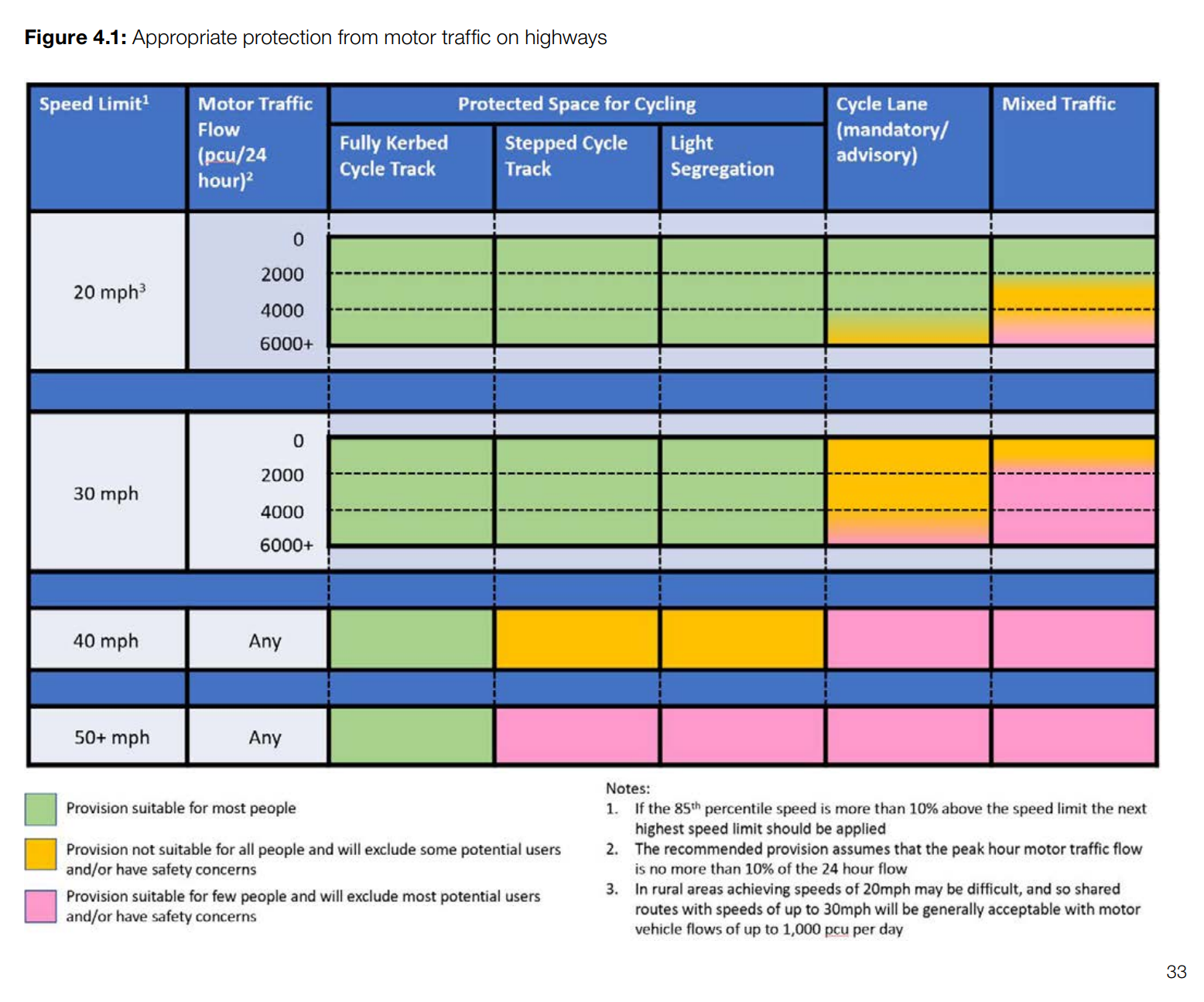
We would like confirmation that the proposed on-road cycle routes have had the volume and speed of traffic measured to ensure it falls within the appropriate “mixed traffic” green section of the cycle infrastructure design guidance:
We would like to learn more about the decision for new one-way streets instead of other interventions (e.g., modal filters). We are particularly concerned that the streets will not allow cycling in both directions, therefore reducing cycling connectivity in the area. This is a perverse outcome when measured against the aims of Places for People schemes.
We would also like further clarity on the proposed speed mitigation on some of the new one-way streets. We note the frequently asked questions document in the consultation material states:
We are proposing that all residential streets are 20mph and with on-street parking reducing the width of the streets, it can lead to slower speeds.
We are confused by this statement. The streets in question already have on-street parking, as such the width and speed will not be reduced.
We urge the council to take in to account local case studies, for example that of Kings Heath where the old one-way streets off Kings Heath High Street allowed through-traffic, had traffic calming and yet were removed as part of that Places for People scheme with the very positive results of a network of quiet side roads that enable cycling. The key element of the proposed new one-way streets in Kings Heath is that they are loops that prevent through traffic. Can the council point to any one-way streets that share the design of those proposed in here that have resulted in the stated aims of making it “safer for people to walk and cycle, and nicer to be outside for children to play and neighbours to chat”? We do not think there are any. We urge the council to re-consider implementing one-way streets, with a specific focus on how the negative impacts will be mitigated to enable safe cycling for all people in both directions along them.
We are concerned about shared use paths for reasons stated earlier. To reiterate, cycle infrastructure design guidance states:
In urban areas, the conversion of a footway to shared use should be regarded as a last resort. Shared use facilities are generally not favoured by either pedestrians or cyclists, particularly when flows are high.
This guidance could not be clearer. We can see how disregarding this guidance may cause problems. For example; there does not appear to be enough room for the proposed shared use path on Woodbrooke Road near to Bournville Village Primary School.
We would like to hear why traffic calming includes the potential for speed cushions (in light of the danger they pose to people cycling, especially those on trikes); and how the other types of potential traffic calming will be made cycle-friendly. The existing traffic calming measures on Northfield Road are ineffective. If they are to be extended, the new measures should be of a higher standard. We point the council to the cycle design guidance on this point, and urge it considers modal filters instead of traffic calming to ensure active travel is enabled and road danger is reduced.
Conclusion
We welcome some elements of this scheme: the signalised and raised zebra crossings, many of which are in useful locations such as on routes to schools. The crossing at the Hole Lane/Heath Road junction is particularly welcome though we are concerned that the difference in levels will be difficult to overcome. We would be pleased to hear how this will be tackled in order to remove the steps and provide easy and safe access for people walking, wheeling and cycling.
We also welcome modal filters, segregated cycle tracks, roads that are genuinely safe for mixed traffic cycling, and effective kerb adjustments at junctions.
We have significant concerns about the shared use cycle routes, the one-way streets, the apparent lack of coherent cycle network planning, general lack of compliance with cycle infrastructure design guidance, the minimal impact on through-traffic, and the apparent lack of systems to measure the aims of the scheme.
We urge the council to address our concerns and non-compliant elements that do not meet the ambitions of the Places for People aims nor the Birmingham Transport Plan. However, given the need to reduce road danger and increase active travel, the action to address the concerning elements must not cause any delay to implementation of the clearly positive and compliant elements.
Better Streets for Birmingham
Better Streets for Birmingham is a community group which campaigns for changes to our travel and planning infrastructure to improve the sustainability, efficiency and safety of our streets. We believe that through connecting Birmingham to reduce car dependency, we will make it a more pleasant place to work, live and play.